Fairly widespread to widespread rainfall with isolated heavy to very heavy rainfall likely over parts of south peninsular India during next 4-5 days
The National Weather Forecasting Centre/Regional Meteorological Centre, New Delhi of the India Meteorological Department (IMD) has said:
♦ An east-west shear zone runs roughly along 11°N Lat. between 3.1 km & 5.8 km above mean sea level and an off shore trough at mean sea level runs from Karnataka coast to Lakshadweep-Maldives area. Under the influence of these systems, fairly widespread to widespread rainfall with isolated heavy to very heavy rainfall likely over parts of south peninsular India during next 4-5 days.
♦ Due to shift of trough northwards and convergence of strong southerly/south-westerly winds from Bay of Bengal over northeast & adjoining east India, widespread rainfall with isolated heavy to very heavy rainfall very likely to continue over northeast & adjoining east
India during next 2-3 days. Isolated extremely heavy rainfall is also likely over Sub-Himalayan West Bengal & Sikkim and Assam & Meghalaya during next 24 hours.
♦ Fairly widespread to widespread rainfall activity with isolated heavy falls also very likely over East Uttar Pradesh during next 3-4 days and over West Uttar Pradesh during 28-29th June.
All India Weather Inference
- The western part of the monsoon trough at mean sea level continue to pass ♦ through Amritsar, Karnal, Bareilly and Gorakhpur and its eastern part lies close to the foothills of the Himalayas.
- The cyclonic circulation over central Pakistan & neighbourhood extending upto 1.5 km above mean sea level persists.
- The trough at 3.1 km above mean sea level from northeast Madhya Pradesh to Marathawada across Vidarbha persists.
- The cyclonic circulation over North Interior Karnataka & neighbourhood extending upto 0.9 km above mean sea level persists.
- The eastwest shear zone roughly along 11°N Lat. between 3.1 km & 5.8 km above mean sea level persists.
- The off shore trough at mean sea level from Karnataka coast to LakshadweepMaldives area persists.
- The cyclonic circulation over Southeast Arabian Sea off Kerala coast at 7.6 km above mean sea level persists.
- The cyclonic circulation over Westcentral Arabian Sea & neighbourhood between 1.5 km & 3.1 km above mean sea level tilting southwards with height persists.
Observations:
Maximum Temperature Departures as on 27-06-2020:
- Maximum temperatures are appreciably above normal (3.1°C to 5.0°C) at many places over Chhattisgarh, Telangana and Madhya Maharashtra; above normal (1.6°C to 3.0°C) at most places over Gujarat, Konkan & Goa, Odisha and interior Karnataka; at a few places over West Uttar Pradesh, East Madhya Pradesh, Gangetic west Bengal, Rayalaseema, Himachal Pradesh, Uttarakhand, Vidarbha, and Tamilnadu, Puducherry& Karaikal and at isolated places over East Rajasthan. They are below normal (-1.6°C to -3.0°C ) at most places over Assam & Meghalaya; at many places over Sub-Himalayan west Bengal & Sikkim, Andaman & Nicobar Islands and Arunachal Pradesh; at a few places over West Madhya Pradesh and East Uttar Pradesh and at isolated places over Haryana, Chandigarh & Delhi and near normal over rest parts of the country. Yesterday, the highest Maximum temperature of 41.8°C reported at Bikaner (West Rajasthan).
Minimum Temperature Departures as on 27-06-2020:
- Minimum temperatures are appreciably above normal (3.1°C to 5.0°C) at a few places over West Rajasthan; at isolated places over Telangana; above normal (1.6°C to 3.0°C) at most places over Uttarakhand and Gujarat Region; at many places over Punjab, Madhya Maharashtra and Andaman & Nicobar Islands; at a few places over Himachal Pradesh, Haryana, Chandigarh & Delhi, East Rajasthan, Saurashtra & Kutch, Rayalaseema and Chhattisgarh; at isolated places over Konkan & Goa and Lakshadweep. They are appreciably below normal (-3.1°C to -5.0°C) at isolated places over East Uttar Pradesh; below normal (-1.6°C to -3.0°C) at a few places over Jammu & Kashmir, Ladakh, Gilgit-Baltistan & Muzaffarabad, Madhya Pradesh, Vidarbha and Assam & Meghalaya; at isolated places over Odisha and Tamil Nadu, Puducherry & Karaikal and near normal over rest parts of the country. The lowest minimum temperature of 20.6°C reported at Churk (East Uttar Pradesh) over the plains of the country.
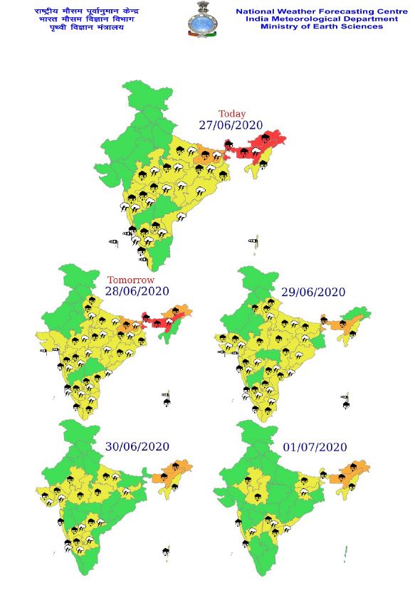
Weather warnings for next 5 days:
Kindly visit www.imd.gov.in for updates.
*****
NB/KGS/(IMD Release)