Current Weather Status and Outlook for next two weeks (19 November to 2 December, 2020)
Significant Features of current week ended on 18 November, 2020
- As predicted, due to an active Western Disturbance, rainfall over northwest India was 220% above Long Period Average (LPA) with large excess rainfall over all the sub-divisions of northwest India except West Rajasthan.
- Northeast monsoon was in active phase over south Peninsula with occurrence of 73% excess rainfall above LPA. Most of the sub-divisions of south Peninsula received excess to large excess rainfall during the week.
Rainfall for week 1: (19 to 25 November, 2020)
- The low pressure area over central parts of south Arabian Sea is very likely to move west-northwestwards and concentrate into a Depression over Southwest Arabian sea during next 48 hours. However, it is not likely to cause any weather over Indian region.
- A trough runs from the cyclonic circulation associated with low pressure area to Comorin area in lower level. Under its influence, scattered to widespread rainfall accompanied with thunderstorm & lightning is very likely over Kerala & Mahe and Lakshadweep on 19th & 20th and scattered rainfall activity is very likely over south Tamilnadu on today, the 19th November and decrease significantly thereafter.
- The Northeast monsoon rainfall activity very likely to be subdued over south peninsular India during next 4 days.
- Thereafter, under the influence of a fresh easterly wave fairly widespread to widespread rainfall accompanied with thunderstorm & lightning and isolated heavy rainfall very likely over Andaman & Nicobar Islands on 21st & 22nd November. The wave is very likely to influence south Peninsular India during 2nd half of the week with likely isolated heavy falls over Tamilnadu from 23rd to 25th November and over Kerala on 24th & 25th November, 2020 (Annexure IV).
- A fresh Western Disturbance very likely affect northwest India during 22-25 November and cause light isolated to scattered rainfall over Western Himalayan Region during the same period (Annexure III).
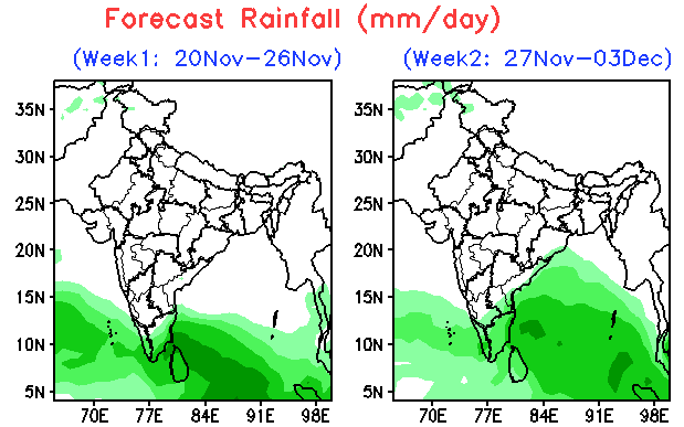
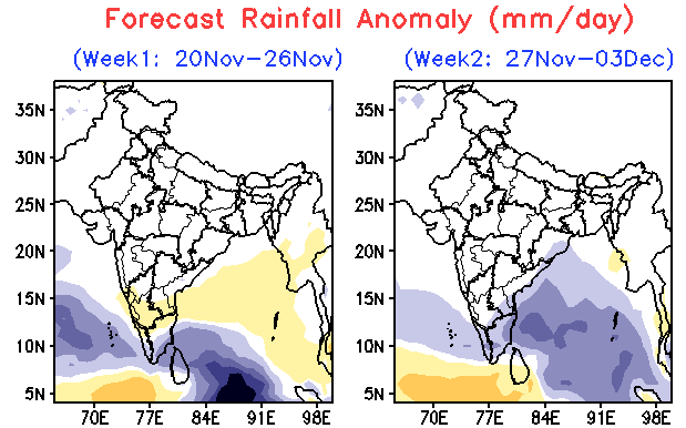
- Cumulatively, above normal rainfall very likely over coastal & south Tamilnadu and below normal over rest parts of the south Peninsular India. Rain/snow activity very likely to be near normal over Western Himalayan Region; No rainfall likely over remaining parts of the country (Annexure V).
Rainfall for week 2: (26 November to 2 December, 2020)
- Due to fresh spell of easterly wave above normal rainfall activity with possibility of isolated heavy falls very likely over extreme south Peninsular India; Below normal or no rainfall likely over remaining parts of the country (Annexure V).
Minimum Temperature for week 1 & 2: (19 November to 2 December, 2020)
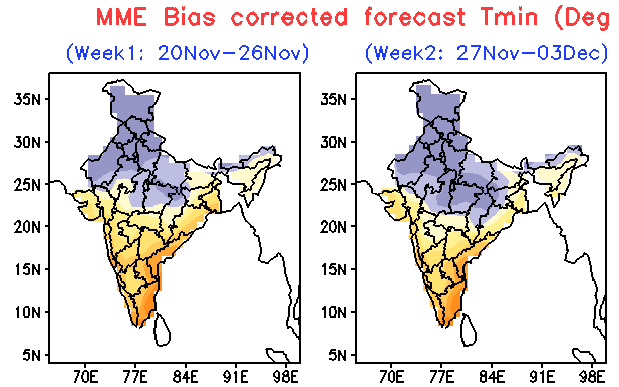
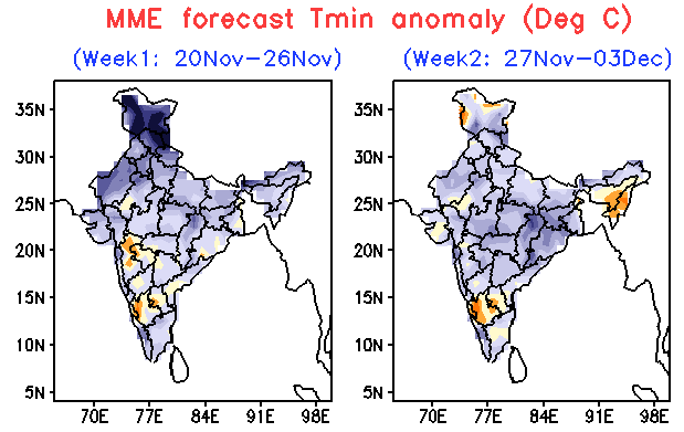
- The minimum temperatures are below normal by about 2-4°C over most parts of northwest India and above normal by 2-6°C over most parts of central, east & north Peninsular India. These are very likely to fall gradually by 2-4°C over northwest India during first half of the 1st week and over Central India by 2-4°C gradually after 24 hours & over East India by 2-3°C after 48 hours during subsequent 3 days.
- Cold wave conditions likely to occur over isolated pockets of northwest India during second half of the 1st week.
- Overall minimum temperatures are very likely to be below normal by 2-6°C over most parts of the northwest India, by 2- 4°C central, east & north Peninsular India during week 1 (Annexure VI).
- These are very likely to be below normal over most parts of the country except parts of south Peninsular India and northeastern states, where there are likely to be normal to above normal (Annexure VI).
Cyclogenesis: (The development or strengthening of an area of low pressure in the atmosphere, resulting in the formation of a cyclone.)
- There is ‘High’ probability for the formation of a Depression over southwest Arabian Sea, during the first half of Week-1 and its west-northwestward movement towards north Somalia coast during 22nd – 24th November, 2020.
- Also there exists a ‘low’ probability for cyclogenesis over southwest Bay of Bengal during the later part of Week 1 (3) No cyclogenesis likely during Week -2.
Annexure V


Annexure VI


For details, please see the enclosed document. Click here.
*****
NB/KGS/(IMD inputs)