Isolated extremely heavy rainfall activity also very likely over Tamilnadu & Puducherry during 24th & 25th
According to the Cyclone Warning Division/ National Weather Forecasting Centre/Regional Meteorological Centre, New Delhi of the India Meteorological Department (IMD): (At 9.30 AM)
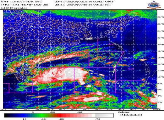
The Depression over southwest and adjoining southeast Bay of Bengal moved nearly northwestwards in past 06 hours and lay centred about 600 km south-southeast of Puducherry and 630 km south-southeast of Chennai. It is very likely to intensify into a cyclonic storm during next 24 hours. It is very likely to move northwestwards and cross Tamil Nadu and Puducherry coasts between Karaikal and Mamallapuram around 25th November 2020 afternoon.
Forecast track and intensity are given below:
|
Date/Time(IST)
|
Position
(Lat. 0N/ long. 0E)
|
Maximum sustained surface
wind speed (Kmph)
|
Category of cyclonic disturbance
|
|
23.11.20/0530
|
9.3/84.5
|
40-50 Gusting To 60
|
Depression
|
|
23.11.20/1730
|
10.0/83.4
|
55-65 Gusting To 75
|
Deep Depression
|
|
24.11.20/0530
|
10.3/82.3
|
65-75 Gusting To 85
|
Cyclonic Storm
|
|
24.11.20/1730
|
10.6/81.5
|
90-100 Gusting To 110
|
Severe Cyclonic Storm
|
|
25.11.20/0530
|
11.2/80.8
|
100-110 Gusting To 120
|
Severe Cyclonic Storm
|
|
25.11.20/1730
|
12.0/79.8
|
90-100 Gusting To 110
|
Severe Cyclonic Storm
|
|
26.11.20/0530
|
13.0/78.5
|
55-65 Gusting To 75
|
Deep Depression
|
Warnings:
(i) Rainfall
Under its influence, the rainfall activity is likely to increase over south peninsular India from 23rd November onwards with fairly widespread to widespread rainfall/thunderstorm activity over Tamilnadu, Puducherry & Karaikal during 24th to 26th November and over south Coastal Andhra Pradesh, Rayalaseema & Telangana during 25th to 26th November, 2020. Isolated extremely heavy rainfall activity also very likely over Tamilnadu & Puducherry during 24th & 25th and over south Coastal Andhra Pradesh & Rayalaseema on 25th & 26th and over Telangana on 26th November, 2020.
|
Sub-Divisions
|
23 Nov 2020*
|
24 Nov 2020*
|
25 Nov 2020*
|
26 Nov 2020*
|
|
Coastal Andhra Pradesh
|
Rainfall at isolated places
|
Rainfall at a few places with heavy rainfall at isolated places
|
Rainfall at most places with isolated heavy to very heavy with extremely heavy falls
|
Rainfall at most places with isolated heavy to very heavy with extremely heavy falls
|
|
Tamilnadu, Puducherry & Karaikal
|
Rainfall at many places with heavy rainfall at isolated places
|
Rainfall at most places with heavy to very heavy rainfall with extremely heavy falls at isolated places
|
Rainfall at most places with heavy to very heavy rainfall at a few places and extremely heavy falls at isolated places
|
Rainfall at many places with heavy rainfall at isolated places
|
|
South Interior Karnataka
|
Rainfall at isolated places
|
Rainfall at a few places
|
Rainfall at a few places with heavy rainfall at isolated places
|
Rainfall at a few places
|
|
Rayalaseema
|
Rainfall at isolated places
|
Rainfall at many places with isolated heavy falls
|
Rainfall at most places with heavy to very heavy rainfall with extremely heavy falls at isolated places
|
Rainfall at most places with heavy to very heavy rainfall with extremely heavy falls at isolated places
|
|
Telangana
|
DRY
|
Rainfall at isolated places
|
Rainfall at a few places with isolated heavy falls
|
Rainfall at most places with heavy to very heavy rainfall with extremely heavy falls at isolated places
|
(ii) Wind warning
Squally weather with wind speed of 45-55 kmph gusting to 65 kmph likely over Southwest & adjoining west-central & southeast Bay of Bengal and along & off Tamil Nadu and south Andhra Pradesh coasts on 23rd November. It would increase gradually becoming 65-75 kmph gusting to 85 kmph over the southwest and adjoining westcentral Bay of Bengal and 55-65 kmph gusting to 75 kmph along and off Tamil Nadu and adjoining South Andhra Pradesh coast and over Gulf of Mannar from 24th November morning. It would further increase becoming 100-110 kmph gusting to 120 kmph over the southwest Bay of Bengal along and off north Tamil Nadu and Puducherry coasts, 65-75 kmph gusting to 85 kmph very likely over adjoining westcentral Bay along and off South Andhra Pradesh, Gulf of Mannar and along and off south Tamil Nadu coast from 25th November morning for subsequent 12 hrs.
(iii) Sea condition
Sea condition is rough to very rough over Southwest & adjoining west-central & southeast Bay of Bengal and along & off Tamil Nadu & Puducherry and south Andhra Pradesh coasts and over Gulf of Mannar. It would gradually become High over the southwest and adjoining west-central Bay of Bengal and along & off Tamil Nadu, Puducherry coast and very rough along and off south Andhra Pradesh coast and also over Gulf of Mannar on 24th . The sea condition would be very high over the southwest and adjoining west-central Bay of Bengal and along & off north Tamil Nadu, Puducherry coasts and high along and off south Tamil Nadu & south Andhra Pradesh coasts and also over Gulf of Mannar on 25th November, 2020.
(iv) Fishermen Warning
Fishermen are advised not to venture into Southwest & adjoining west-central & southeast Bay of Bengal, Gulf of Mannar and along & off Tamil Nadu, Puducherry and south Andhra Pradesh coasts during 23-25th November. Also the fishermen out at Sea are advised to return to the coast and avoid the above sea area.
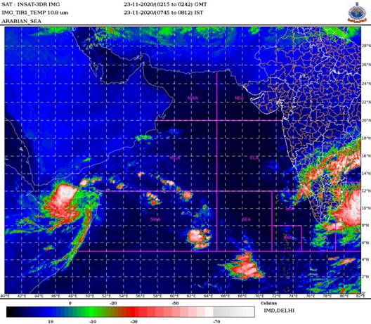
The severe cyclonic storm “GATI” over north Somalia moved nearly westwards with a speed of about 09 kmph during past 06 hours and weakened into a Cyclonic Storm over the same region and lay centred at 150 km south-southwest of Ras Binnah (Somalia). It is very likely to move nearly westwards and weaken gradually into a deep depression during next 6 hours.
|
Date/Time(IST)
|
Position
(Lat. 0N/ long. 0E)
|
Maximum sustained surface
wind speed (Kmph)
|
Category of cyclonic disturbance
|
|
23.11.20/0530
|
10.5/50.0
|
80-90 Gusting TO 100
|
Cyclonic Storm
|
|
23.11.20/1130
|
10.6/48.8
|
55-65 Gusting TO 75
|
Deep Depression
|
|
23.11.20/1730
|
10.6/47.6
|
40-50 Gusting TO 60
|
Depression
|
|
23.11.20/2330
|
10.7/46.4
|
20-30 Gusting TO 40
|
Low Pressure Area
|
As the system has moved away from the Indian coast no adverse weather associated with this system is likely over the west coast of India. However, warnings for Ship and Fishermen prevail over southwest Arabian Sea as specified below.
(i) Wind warning
Gale wind speed reaching 80-90 kmph gusting to 100 kmph is prevailing over Gulf of Eden along and of Somalia coast and 60-70 kmph gusting to 80 kmph prevails over southwest Arabian Sea along and off north Somalia coast. It will gradually decrease becoming 40-50 kmph gusting to 60 kmph over the above area by 23rd November evening.
(ii) Sea condition
Sea condition will be high to very rough over Gulf of Eden and southwest Arabian Sea along and off north Somalia coast till 23rd November evening and improve thereafter.
(iii) Fishermen Warning
Fishermen are advised not to venture into Gulf of Eden and southwest Arabian Sea along and off north Somalia coast till 23rd November evening.
SEVERE CYCLONIC STORM OVER ARABIAN SEA
DEPRESSION OVER BAY OF BENGAL
Please CLICK HERE for graphics.
Kindly download MAUSAM APP for location specific forecast & warning, MEGHDOOT APP for Agromet advisory and DAMINI APP for Lightning Warning.
***
NB/KGS/(IMD Release)