A Well Marked Low Pressure Area lies over Southeast Bay of Bengal & adjoining areas of South Andaman Sea and Equatorial Indian Ocean; It is very likely to concentrate into a Depression during next 36 hours and likely to intensify further thereafter.
According to the National Weather Forecasting Centreof the India Meteorological Department (IMD):
Significant Weather Features
♦ A Well Marked Low Pressure Area lies over Southeast Bay of Bengal & adjoining areas of South Andaman Sea and Equatorial Indian Ocean with associated cyclonic circulation extending upto mid tropospheric levels. It is very likely to concentrate into a Depression during next 36 hours and likely to intensify further thereafter. It is likely to move westnorthwestwards and reach near south Tamil Nadu coast around 02nd December, 2020.
♦ Under the influence of the above system;
- Scattered to Widespread rainfall activity very likely over Tamilnadu, Puducherry & Karaikal, Kerala & Mahe, Lakshadweep, south coastal Andhra Pradesh and south Rayalaseema during 01st-03rd December, 2020.
- ii) Isolated heavy to very heavy rainfall with moderate thunderstorm & lightning very likely over Tamil Nadu, Puducherry & Karaikal during 01st-03rd December and isolated extremely rainfall likely over south Tamilnadu and south Kerala on 02nd December 2020. Isolated heavy falls with moderate thunderstorm & lightning also very likely over south Coastal Andhra Pradesh, Rayalseema and Lakshadweep area during 02nd-03rd December, 2020.
Meteorological Analysis (Based on 0830 hours IST)
♦ The Low Pressure Area over South Andaman Sea and adjoining areas of Southeast Bay of Bengal & Equatorial IndianOcean now seen as a Well Marked Low Pressure Area over Southeast Bay of Bengal & adjoining areas of South AndamanSea andEquatorial Indian Ocean with associated cyclonic circulation extending upto mid tropospheric levels. It is very likely toconcentrate into a Depression during next 36 hours and likely to intensify further thereafter. It is likely to move westnorthwestwardsand reach near south Tamil Nadu coast around 02nd December, 2020.
♦ The Western Disturbance as a trough in mid tropospheric westerlies persists.
♦ A Cyclonic Circulation lies over Haryana & adjoining West Uttar Pradesh.
♦ A Cyclonic Circulation lies over Eastcentral Arabian Sea off Maharashtra coast.
♦ The Cyclonic Circulation over Northeast Bangladesh & neighbourhood hasbecome less marked.
♦ The cyclonic circulation over Sub-Himalayan West Bengal & Sikkim at 3.1 km above mean sea level has become lessmarked.
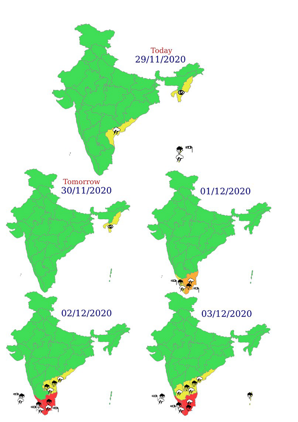
Weather Warning during next 5 days
29 November (Day 1):
♦ Heavy rainfall at isolated places very likely over Andaman & Nicobar Islands.
♦ Thunderstorm with lightning at isolated places very likely over Coastal Andhra Pradesh & Yanam and Andaman & Nicobar Islands.
♦ Dense fog very likely at isolated places over Tripura.
♦ Squally Weather (wind speed reaching 40-50 kmph gusting to 60 kmph) very likely over Southeast Bay of Bengal and South AndamanSea.
Fishermen are advised not to venture into these areas.
30 November (Day 2):
♦ Dense fog very likely at isolated places over Tripura.
♦ Squally Weather (wind speed reaching 45-55 kmph gusting to 65 kmph) very likely over central parts of South Bay of Bengal.Fishermen are advised not to venture into these areas.
01 December (Day 3):
♦ Heavy to very heavy rainfall very likely at isolated places over South Tamilnadu; heavy rainfall at isolatedplaces over north Tamil Nadu, Puducherry & Karaikal and Kerala & Mahe.
♦ Thunderstorm with lightning very likely at isolated places over Kerala & Mahe and Tamilnadu, Puducherry & Karaikal.
♦ Squally Weather (wind speed reaching 50-60 kmph gusting to 70 kmph) very likely over Southwest Bay of Bengal, Comorin Area, Gulfof Mannar and Tamilnadu-Kerala coasts.
Fishermen are advised not to venture into these areas.
02 December (Day 4):
♦ Heavy to very heavy rainfall at a few places with extremely heavy falls at isolated places likely over southTamil Nadu and south Kerala; heavy to very heavy rainfall at isolated places over north Tamilnadu, Puducherry & Karaikal and northKerala & Mahe; heavy rainfall at isolated places over Coastal Andhra Pradesh & Yanam, Rayalseema and Lakshadweep.
♦ Thunderstorm with lightning likely at isolated places over Coastal Andhra Pradesh & Yanam, Rayalaseema, Lakshadweep, Kerala &Mahe and Tamilnadu, Puducherry & Karaikal.
♦ Squally Weather (wind speed reaching 60-70 kmph gusting to 80 kmph) likely along & off Kerala coast, Comorin Area and Gulf ofMannar and along & off south Tamilnadu coast and (wind speed reaching 50-60 kmph gusting to 70 kmph) over Southeast Arabian Sea
and Lakshadweep-Maldives areas.
Fishermen are advised not to venture into these areas.
03 December (Day 5): ♦ Heavy to very heavy rainfall at isolated places over south Tamilnadu, south Kerala and Lakshadweep; heavyrainfall at isolated places over Andaman & Nicobar Islands, Coastal Andhra Pradesh & Yanam, Rayalseema and north Tamilnadu,Puducherry & Karaikal.
♦ Thunderstorm with lightning likely at isolated places over Coastal Andhra Pradesh & Yanam, Rayalaseema, South Interior Karnataka,Lakshadweep, Kerala & Mahe and Tamilnadu, Puducherry & Karaikal.
♦ Squally Weather (wind speed reaching 50-60 kmph gusting to 70 kmph) likely over Southeast Arabian Sea along & off Kerala coastand Lakshadweep area.
Fishermen are advised not to venture into these areas.


Please click here for Graphics/Maps.
Kindly download MAUSAM APP for location specific forecast & warning, MEGHDOOT APP for Agromet advisory and DAMINI APP for Lightning Warning.
***
NB/KGS/(IMD Release)