Cyclonic Storm ‘Burevi’ over southwest Bay of Bengal (Cyclone Warning for South Tamilnadu and South Kerala coasts: Orange Message)
According to the Cyclone Warning Division of the India Meteorological Department (IMD):
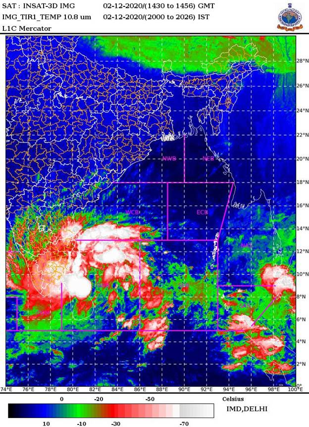
The Cyclonic Storm ‘Burevi’ over southwest Bay of Bengal moved west-northwestwards with a speed of 13 kmph during past six hoursand lay centered at 1730 hrs IST of today, the 02nd December 2020 over southwest Bay of Bengal about 70 km east-northeast of Trincomalee (Sri Lanka), 290 km east-southeast of Pamban (India) and 480 km east-northeast of Kanniyakumari (India).
It is very likely to move west-northwestwards and cross Sri Lanka coast around latitude 9.00N, to north of Trincomalee by midnight of 2nd December as a Cyclonic Storm with a wind speed of 80-90 kmph gusting to 100 kmph. It is very likely to move nearly west-northwestwards thereafter, emerge into Gulf of Mannar and adjoining Comorin area on 3rd December morning.
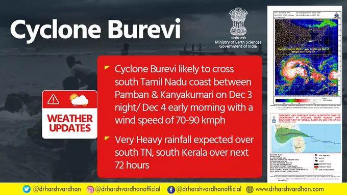
The Cyclonic Storm with wind speed of 70-80 gusting to 90 kmph would be centered very close to Pamban around noon of 3rd December. It would then move nearly west-southwestwards across Pamban area by afternoon and cross south Tamilnadu coast between Pamban and Kanniyakumari during 3rd December night and 4th December early morning as a Cyclonic Storm with wind speed of 70-80 gusting to 90 kmph. Thus its impact on south Tamilnadu coastal districts is very likely to commence from 3rd December forenoon initially over Ramanathapuram district and gradually towards Kanniyakumari district.
Forecast track and intensity are given below:
Date/Time(IST)
|
Position
(Lat. 0N/ long. 0E)
|
Maximum sustained surface
wind speed (Kmph)
|
Category of cyclonic disturbance
|
02.12.20/1730
|
8.8/81.8
|
80-90 gusting to 100
|
Cyclonic Storm
|
02.12.20/2330
|
9.0/81.0
|
80-90 gusting to 100
|
Cyclonic Storm
|
03.12.20/0530
|
9.2/80.1
|
70-80 gusting to 90
|
Cyclonic Storm
|
03.12.20/1130
|
9.2/79.5
|
70-80 gusting to 90
|
Cyclonic Storm
|
03.12.20/1730
|
9.1/78.9
|
70-80 gusting to 90
|
Cyclonic Storm
|
04.12.20/0530
|
9.0/78.1
|
60-70 gusting to 80
|
Cyclonic Storm
|
04.12.20/1730
|
8.8/77.3
|
50-60 gusting to 70
|
Deep Depression
|
Warnings:
(i) Rainfall
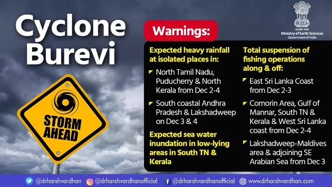
· Heavy to very heavy rainfall at a few places with isolated Extremely heavy falls very likely over south Tamilnadu (Ramanathapuram, Thoothukudi, Tirunelveli, Kanniyakumari, Tenkasi and Sivagangai districts) on 2nd& 3rdDecember, 2020; over south Kerala (Thiruvananthapuram, Kollam, Pathanamthitta and Alappuzah) on 3rdDecember and isolated heavy to very heavy rainfall likely over south Tamilnadu on 4th December 2020 and south Kerala on 2nd& 4th December, 2020.
· Heavy to very heavy rainfall at isolated places very likely over north Tamilnadu, Puducherry, Mahe& Karaikal and north Kerala on 3rd December, isolated heavy rainfall on 2nd& 4th December.
· Heavy rainfall at isolated places very likely over south Coastal Andhra Pradesh and Lakshadweep on 3rd& 04th December.
|
Sub-Divisions
|
02 Dec 2020*
|
03 Dec 2020*
|
04 Dec 2020*
|
|
South Tamilnadu
|
Rainfall at most places with heavy to very heavy rainfall at few places and extremely heavy fall at isolated places
|
Rainfall at most places with heavy to very heavy rainfall at few places and extremely heavy fall at isolated places
|
Rainfall at many places with heavy to very heavy rainfall at isolated places
|
|
North Tamilnadu, Puducherry & Karaikal
|
Rainfall at many places with heavy rainfall at isolated places
|
Rainfall at many places with heavy to very heavy rainfall at isolated places
|
Rainfall at many places with heavy fall at isolated places
|
|
South Kerala
|
Rainfall at most places with heavy to very heavy rainfall at isolated places
|
Rainfall at most places with heavy to very heavy rainfall at few places and extremely heavy fall at isolated places
|
Rainfall at many places with heavy to very heavy rainfall at isolated places
|
|
North Kerala & Mahe
|
Rainfall at many places with heavy rainfall at isolated places
|
Rainfall at most places with heavy to very heavy rainfall at isolated places
|
Rainfall at a few places with heavy fall at isolated places
|
|
South Coastal Andhra Pradesh
|
Rainfall at a few places
|
Rainfall at a few places with heavy rainfall at isolated places
|
Rainfall at a few places with heavy rainfall at isolated places
|
|
Lakshadweep
|
Rainfall at a few places
|
Rainfall at many places with heavy falls at isolated places
|
Rainfall at most places with heavy to very falls at isolated places
|
(ii) Wind warning
- Gale wind speed reaching 80-90 kmph gusting to 100 kmph continues to prevail over southwest Bay of Bengal and along & off Sri Lanka coast during next 12 hours. It will gradually decrease thereafter.
- Squally wind speed reaching 45-55 kmph gusting to 65 kmph very likely over Comorin Area, Gulf of Mannar and along and off south Tamilnaducoast (Ramanathapuram, Thoothukudi, Tirunelveli and Kanniyakumari districts) and south Kerala coast (Thiruvananthapuram, Kollam, Pathanamthitta and Alappuzah districts). It will gradually increase becoming 55-65 kmph gusting to 75 kmph from early hours of 3rd December and 70-80 kmph gusting to 90 kmph from 3rd December forenoon for subsequent 24 hours and decrease thereafter.
- Squally wind speed reaching 45-55 kmph gusting to 65 kmph very likely over Lakshadweep-Maldives area and adjoining southeast Arabian Sea from 3rd December morning for next 48 hours.
(iii) Storm Surge:
- Storm surge of about 1.0 m height above astronomical tide is very likely to inundate low lying areas of south coastal Tamilnadu (Ramanathapuram, Thoothukudi, Tirunelveli and Kanniyakumari districts) during the time of landfall.
(iii) Sea condition
- Sea conditions is very rough to high over southwest Bay of Bengal and along & off east Sri Lanka coast and the same will continue till mid-night of 3rdDecember and gradually improve thereafter.
- It will be rough to very rough over Comorin Area, Gulf of Mannar, along & off south Tamilnadu-Kerala and west Sri Lanka coast on 2nd and very rough to high on 3rd and 4th December.
- Sea condition will be rough to very rough over Lakshadweep-Maldives area and adjoining southeast Arabian Sea during 3rd – 5th December.
(iv) Damage expected over south Tamilnadu (Kanniyakumari, Tirunelveli, Thoothukudi and Ramanathapuram districts) and south Kerala (Thiruvananthapuram, Kollam, Pathanamthitta and Alappuzah districts)
- Damage to thatched huts.
- Minor damage to power and communication lines due to breaking of branches.
- Major damage to Kutcha and minor damage to Pucca roads.
- Some damage to paddy crops, banana, papaya trees and orchards.
- Sea water inundation in low lying areas after erosion of Kutcha embankments.
(v) Fishermen warning and Action suggested
- Total suspension of fishing operation during 2nd to 5th December over the areas as mentioned below.
- Fishermen are advised not to venture into southwest Bay of Bengal and along & off east Sri Lanka coast from 2nd to 3rd December; Comorin Area, Gulf of Mannar and south Tamilnadu-Kerala and west Sri Lanka coasts from 2nd to 4th December, over Lakshadweep-Maldives area & adjoining southeast Arabian Sea from 3rd to 5th December.
For details in Graphics, Please click here.
Kindly download MAUSAM APP for location specific forecast & warning, MEGHDOOT APP for Agromet advisory and DAMINI APP for Lightning Warning.
***
NB/KGS/(IMD Release)