Under a fresh Western Disturbance influence, scattered to fairly widespread rain/snow likely over Jammu & Kashmir, Ladakh, Gilgit-Baltistan & Muzaffarabad and Himachal Pradesh and isolated rain/snow over Uttarakhand during 22nd-24th
According to the National Weather Forecasting Centre of the India Meteorological Department (IMD):
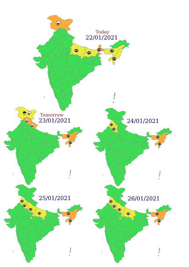
All India Weather Bulletin (Morning) Dated 22-01-2021 with following significant weather features:
♦ Under a fresh Western Disturbance influence, scattered to fairly widespread rain/snow likely over Jammu & Kashmir, Ladakh, Gilgit-Baltistan & Muzaffarabad and Himachal Pradesh and isolated rain/snow over Uttarakhand during 22nd-24th and very light/light rain/thundershower likely at isolated places over Punjab and Haryana, Chandigarh & Delhi on 23rd January, 2021. Heavy rain/snow very likely at isolated places over Jammu & Kashmir, Ladakh, GilgitBaltistan & Muzaffarabad on 23rd January, 2021. Isolated thunderstorm with lightning & hail also likely over Jammu & Kashmir, Ladakh, Gilgit-Baltistan & Muzaffarabad on 22nd and over Himachal Pradesh and Uttarakhand on 23rd January, 2021.
♦ Rise in minimum temperatures by 2-4°C very likely during next 48 hours (23rd-24th January) and fall by 2-4°C during subsequent 48 hours (25th-26th January) over the plains of Northwest India.
♦ Dense to very dense Fog in isolated pockets very likely over Assam & Meghalaya and Nagaland, Manipur, Mizoram & Tripura during 23rd-26th and over Sub-Himalayan West Bengal during morning hours of 23rd January, 2021.
Weather Outlook:
22 January (Day 1): ♦ Dense to Very Dense Fog in isolated pockets very likely over Sub-Himalayan West Bengal and Dense Fog in isolated pockets over East Uttar Pradesh, Bihar, Assam & Meghalaya and Nagaland, Manipur, Mizoram & Tripura.
♦ Thunderstorm accompanied with lightning & hail at isolated places very likely over Jammu & Kashmir, Ladakh, Gilgit-Baltistan & Muzaffarabad.
♦ Strong Winds (speed reaching 45-55 kmph) very likely over Northwest Arabian Sea. Fishermen are advised not to venture into this area.
23 January (Day 2): ♦ Dense to Very Dense Fog in isolated pockets very likely over Assam
& Meghalaya and Nagaland, Manipur, Mizoram & Tripura.
♦ Thunderstorm accompanied with lightning & hail at isolated places very likely over Himachal Pradesh and Uttarakhand; with lightning at isolated places over Jammu & Kashmir, Ladakh, Gilgit-Baltistan & Muzaffarabad.
♦ Heavy rain/snow at isolated places very likely over Jammu & Kashmir, Ladakh, Gilgit-Baltistan & Muzaffarabad.
♦ Strong Winds (speed reaching 45-55 kmph) very likely over Northwest Arabian Sea. Fishermen are advised not to venture into this area.
24 January (Day 3): ♦ Dense to Very Dense Fog in isolated pockets very likely over Assam
& Meghalaya and Nagaland, Manipur, Mizoram & Tripura and Dense Fog in isolated pockets over Punjab and Haryana, Chandigarh & Delhi.
25 January (Day 4): ♦ Dense to Very Dense Fog in isolated pockets likely over Assam & Meghalaya and Nagaland, Manipur, Mizoram & Tripura and Dense Fog in isolated pockets over Punjab, Haryana, Chandigarh & Delhi and Uttar Pradesh.
26 January (Day 5): ♦ Dense to Very Dense Fog in isolated pockets likely over Assam & Meghalaya and Nagaland, Manipur, Mizoram & Tripura and Dense Fog in isolated pockets over Punjab, Haryana, Chandigarh & Delhi and Uttar Pradesh.
" Current Weather Status and Outlook for next two weeks (21 January to 3 February, 2021) ".
Salient Features
- Northeast Monsoon rains have ceased over Tamilnadu, Puducherry & Karaikal, Kerala & Mahe and adjoining areas of Andhra Pradesh and Karnataka from 19th January 2021.
- An easterly waves caused scattered to fairly widespread rainfall/thunderstorms over extreme south Peninsula with isolated heavy falls over Tamil Nadu, Puducherry & Karaikkal during the beginning of the week (14 to 20 January, 2021).
- As a result, south Peninsula received 220% and Tamil Nadu, Puducherry & Karaikkal received 727% above Long Period Average (LPA) during past week.
- Under the influence of fresh Western Disturbance, scattered to fairly widespread rain/snow likely over Jammu & Kashmir, Ladakh, Gilgit-Baltistan & Muzaffarabad and Himachal Pradesh and isolated rain/snow over Uttarakhand during 22nd-24th and very light/light rain/thundershower likely at isolated places over Punjab and Haryana, Chandigarh & Delhi on 23rd January, 2021. Heavy rain/snow very likely at isolated places over Jammu & Kashmir, Gilgit-Baltistan & Muzaffarabad on 23rd January, 2021.
- No significant change in minimum temperatures very likely till tomorrow morning hours; rise by 2-4°C during 23rd-24th January and fall by 2-4°C during subsequent 48 hours (25th-26th January, 2021) over the plains of Northwest India.
- No cold wave conditions likely over northern India during next 4-5 days.
Dense to very dense Fog in isolated pockets very likely over Assam & Meghalaya and Nagaland, Manipur, Mizoram & Tripura during 22nd-26th and over Sub-Himalayan West Bengal during morning hours of 22nd-23rd and in some pockets over Punjab and Haryana, Chandigarh & Delhi in the morning hours of 22nd, 25th & 26th January, 2021.
Plese click here for detailed weather outlook for two week
Plese click here for Impact base
Kindly download MAUSAM APP for location specific forecast & warning, MEGHDOOT APP for Agromet advisory and DAMINI APP for Lightning Warning & visit state MC/RMC websites for district wise warning.
*****
NB/KGS/(IMD inputs)