Ministry of Earth Sciences
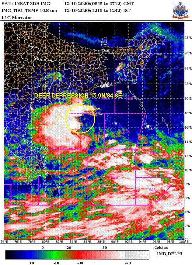
Depression over Westcentral Bay of Bengal intensifies into a Deep Depression
It lays centred over the same region about 250 km south-southeast of Vishakhapatnam, 290 km east-southeast of Kakinada (Andhra Pradesh) and 330 km east-southeast of Narsapur (Andhra Pradesh)
Extremely heavy rainfall (more than 20 cm per day) at isolated places would occur over east & west Godavari, Vishakhapatnam, Vijayanagaram & Srikakulam districts of north coastal Andhra Pradesh
Sea condition will be rough to very rough over westcentral & adjoining northwest Bay of Bengal, southwest Bay of Bengal and along & off Odisha-Andhra Pradesh-Tamil Nadu & Puducherry coasts
प्रविष्टि तिथि:
12 OCT 2020 3:17PM by PIB Delhi
According to the Cyclone Warning Division of the India Meteorological Department (IMD):
Yesterday's depression over westcentral Bay of Bengal (BoB) moved west-northwestwards, intensified into a deep depression and lay centred at 1130 hrs IST of 12th October, 2020 over the same region near latitude 15.9°N and longitude 84.8°E, about 250 km south-southeast of Vishakhapatnam, 290 km east-southeast of Kakinada (Andhra Pradesh) and 330 km east-southeast of Narsapur (Andhra Pradesh).
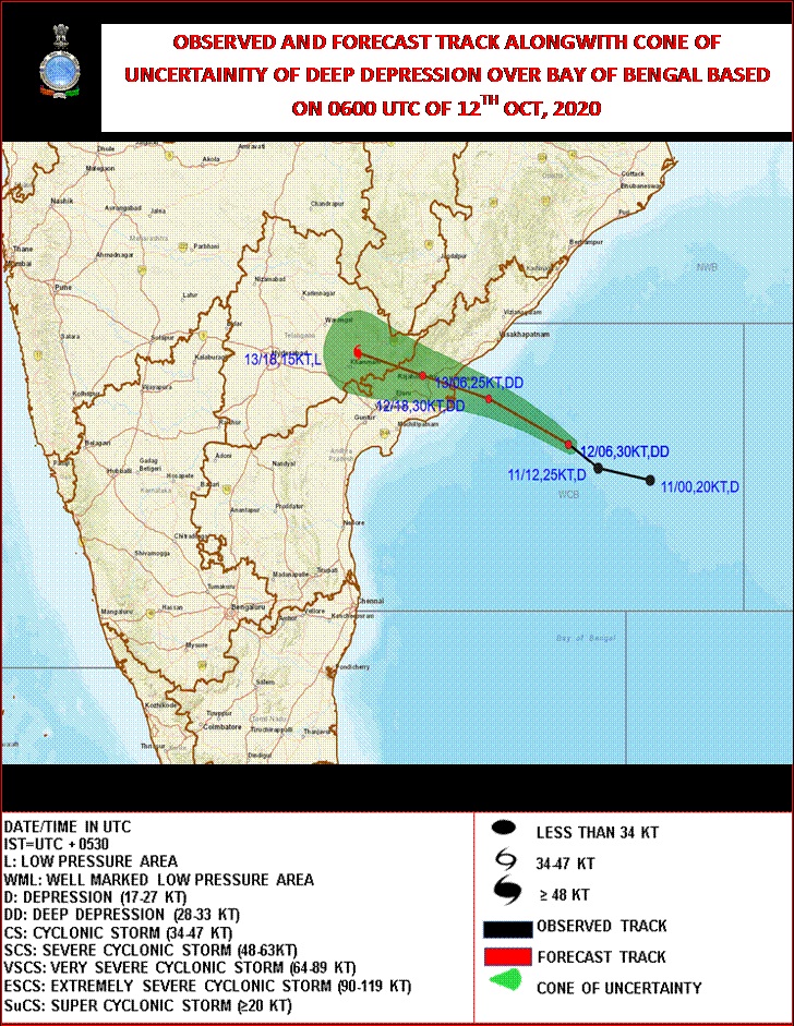
It is very likely to move west-northwestwards and cross north Andhra Pradesh coast between Narsapur & Vishakhapatnam, close to Kakinada during the early morning of 13th October 2020 as a Deep Depression with maximum sustained wind speed of 55-65 kmph gusting to 75 kmph.
Forecast track and intensity are given in the following table:
Date/Time(IST)
|
Position
(Lat. 0N/ long. 0E)
|
Maximum sustained surface
wind speed (Kmph)
|
Category of cyclonic disturbance
|
12.10.20/1130
|
15.9/84.8
|
50-60 gusting to 70
|
Deep Depression
|
12.10.20/2330
|
16.7/83.1
|
55-65 gusting to 75
|
Deep Depression
|
13.10.20/1130
|
17.1/81.7
|
45-55 gusting to 65
|
Depression
|
13.10.20/2330
|
17.5/80.3
|
25-35 gusting to 45
|
Well marked low
|
Warnings:
(i) Rainfall warning
- 12th October 2020: Light to moderate rainfall at most places with heavy to very heavy falls at a few places and Extremely heavy rainfall (>20 cm per day) at isolated places would occur over east & west Godavari, Vishakhapatnam, Vijayanagaram & Srikakulam districts of north coastal Andhra Pradesh and Yanam, heavy to very heavy falls at isolated places over Ganjam, Gajapati, Koraput, Raygada, Navrangpur, Malkangiri, Khurda & Puri districts of south Odisha, Krishna district of south coastal Andhra Pradesh, Kurnool District of Rayalaseema, Telangana, south Konkan & Goa, south Madhya Maharashtra, Marathwada, Karnataka, & north Kerala and heavy rainfall at isolated places over south Chhattisgarh
- 13th October 2020: Light to moderate rainfall at most places with heavy to very heavy falls at a few places and Extremely heavy rainfall (>20 cm per day) at isolated places would occur over Telangana, heavy to very heavy falls at isolated places over Karnataka, Rayalaseema, south Konkan & Goa, Madhya Maharashtra & Marathawada and heavy falls at isolated places over north coastal Andhra Pradesh, south Odisha, and Vidarbha.
- 14th October 2020: Light to moderate rainfall at most places with heavy to very heavy falls at a few places and Extremely heavy rainfall (>20 cm per day) at isolated places would occur over north Madhya Maharashtra, heavy to very heavy falls at isolated places over Konkan & Goa, south Madhya Maharashtra and Marathawada and heavy falls at isolated places over coastal & south interior Karnataka.
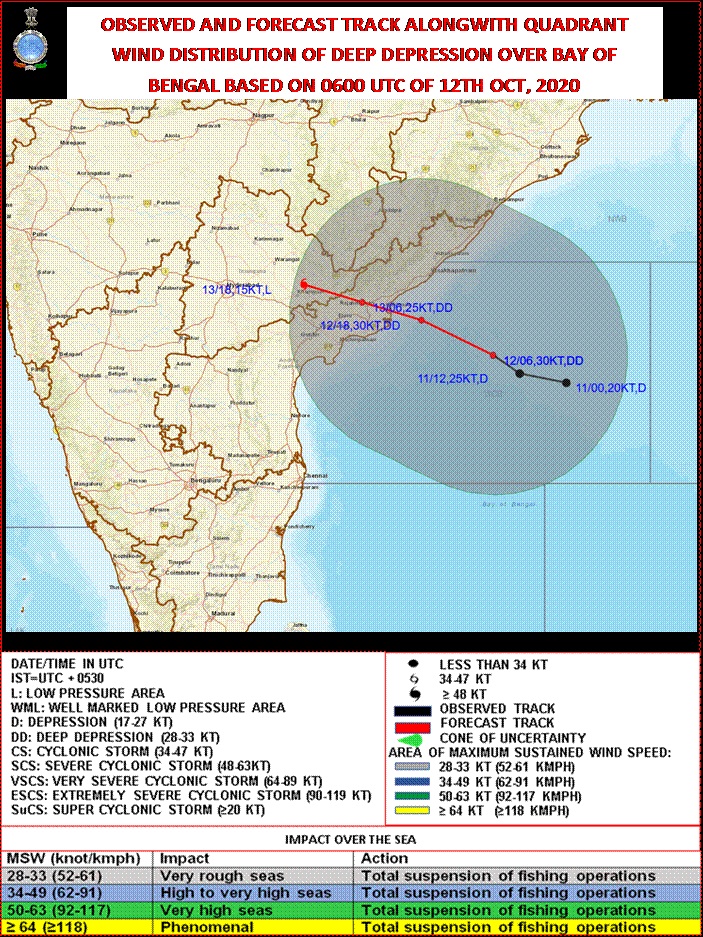
(ii) Wind warning
- 12th October 2020: Squally wind speed reaching 50-60 kmph gusting to 70 kmph is prevailing over west central & adjoining southwest Bay of Bengal and along & off south Odisha-Andhra Pradesh-Tamil Nadu & Puducherry coasts & 40-50 kmph gusting to 60 kmph is also prevailing over northwest Bay of Bengal and north Odisha coast.
- 13th October 2020: Squally wind speed would increase becoming 55-65 kmph gusting to 75 kmph over west central Bay of Bengal and along & off Andhra Pradesh coast and 50-60 kmph gusting to 70 kmph over adjoining northwest Bay of Bengal, southwest Bay of Bengal and along & off Odisha- Tamil Nadu & Puducherry coasts from the evening of 12th October 2020 till the noon of 13th October.
- Squally winds, speed reaching 45-55 kmph gusting to 65 kmph are also likely to prevail over Gulf of Mannar on 12th & 13th October 2020.
(iii) Sea condition
- Sea condition will be rough to very rough over westcentral & adjoining northwest Bay of Bengal, southwest Bay of Bengal and along & off Odisha-Andhra Pradesh-Tamil Nadu & Puducherry coasts till 13th October evening and over Gulf of Mannar during 12th- 13th October 2020.
(iv) Fishermen Warning
- Fishermen are advised not to venture into westcentral , northwest & southwest Bay of Bengal, and along & off Andhra Pradesh-Odisha-Tamil Nadu & Puducherry coasts till 13th October evening and over Gulf of Mannar during 12th-13th October 2020.
(v) Damage expected over east & west Godavari, Vishakhapatnam, Vijayanagaram & Srikakulam districts of north coastal Andhra Pradesh and Yanam.
- Damage to thatched huts. Minor damage to power and communication lines due to breaking of branches. Damage to loose / unsecured structures.
- Some breaches in Kutcha road due to heavy rainfall.
- Some damage to paddy crops, banana, papaya trees and orchards & drumstick trees and Horticultural crops. Minor damage to coastal agriculture due to salt spray. Minor damage to Kutcha embankments.
The system is under continuous surveillance and the concerned state governments are being informed regularly.
For details kindly visit www.rsmcnewdelhi.imd.gov.in, www.imd.gov.in
****
NB/KGS/(IMD release)
(रिलीज़ आईडी: 1663687)
आगंतुक पटल : 721