PIB Backgrounder
GAGAN: Navigating India’s Skies with Precision
Posted On:
01 JUL 2026 2:50PM by PIB Delhi
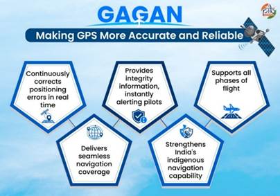
GAGAN (GPS Aided GEO Augmented Navigation) is India's indigenous Satellite-Based Augmentation System developed by the Indian Space Research Organisation (ISRO) and the Airports Authority of India. It enhances GPS accuracy and provides integrity information for safer aircraft navigation. Certified to international standards, GAGAN supports satellite-based landing and serves sectors beyond aviation. By strengthening indigenous navigation capabilities, GAGAN reinforces India's vision of technological self-reliance and global leadership in satellite navigation.
The Need for Precise Navigation: Why India Created GAGAN
Aviation requires highly accurate navigation, where even slightest positioning errors can affect flight safety. While Global Positioning System (GPS)helps aircraft determine their position, its signals can be affected by atmospheric conditions and other sources of error. As India spreads its wings as a major aviation market, the need for precise and reliable navigation has become has become a national priority.
To address this need, the Indian Space Research Organisation (ISRO) and the Airports Authority of India (AAI) jointly developed the GPS Aided GEO Augmented Navigation (GAGAN) system. It is a Satellite-Based Augmentation System (SBAS), a technology that improves GPS by providing real-time correction and integrity information. Integrity information alerts pilots if a GPS signal is unsuitable for navigation.
The GAGAN project has been fully operational since 2015. It has placed India among a select group of countries with an operational SBAS, alongside the United States, Europe, and Japan. Today, GAGAN supports safer aircraft operations across Indian airspace and has applications beyond aviation. It also strengthens India's indigenous navigation capability and advances the country's vision of Aatmanirbhar Bharat.
GAGAN in India's Navigation Ecosystem
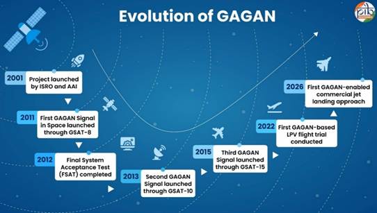
Since its launch, GAGAN has steadily evolved into a globally recognised Navigational Satellite. Over the years, it has achieved key certifications and operational milestones. Its latest achievement came in June 2026, when the Directorate General of Civil Aviation (DGCA) successfully conducted India's first satellite-based landing system approach on a commercial jet aircraft using GAGAN.
GAGAN operates through an integrated network of ground stations, communication systems, and geostationary satellites. These elements monitor GPS signals in real-time, calculate corrections, and broadcast enhanced navigation information to aircraft.
|
Key Elements
|
No. of Elements Deployed
|
Role
|
|
Indian Reference Stations (INRES)
|
15
|
Continuously monitor GPS signals across the country and detect any errors.
|
|
Indian Master Control Centres (INMCC)
|
2
|
Process data received from all reference stations, calculate signal corrections, and generate integrity information.
|
|
Indian Land Uplink Stations (INLUS)
|
3
|
Transmit correction and integrity information from the ground to GAGAN satellites.
|
|
Communication Networks
|
4
|
Connect all GAGAN stations and enable secure, real-time transmission of navigation data.
|
|
Geostationary Satellites with GAGAN Payloads
|
3
|
Broadcast corrected navigation signals across the service area.
|
Did you know? Geostationary satellites orbit at the same speed as the Earth's rotation, making them appear fixed over the same location. GSAT-8, GSAT-10, and GSAT-15 are India's geostationary satellites that carry GAGAN payloads. These are specialised navigation systems that broadcast GAGAN's correction and integrity information to users.
By enhancing navigation accuracy and seamless operations across the region, it continues to reinforce India's leadership in satellite-enabled aviation services.
India's Indigenous Navigation Ecosystem
The integrated architecture of GAGAN forms an important part of India's broader satellite navigation programme. Alongside GAGAN, India has developed the Navigation with Indian Constellation (NavIC), its indigenous regional navigation satellite system. While NavIC provides positioning, navigation and timing services, GAGAN enhances GPS signals to support precise aircraft navigation and landing.
|
GAGAN
|
NavIC
|
|
Satellite-Based Augmentation System (SBAS)
|
Independent regional navigation satellite system
|
|
Improves GPS through real-time corrections and integrity information
|
Provides positioning, navigation and timing services
|
|
Supports civil aviation across the Indian Flight Information Region
|
Coverage area includes India and a region up to 1500 km beyond Indian boundary
|
Did You Know? In 2025, India signed an agreement with South Africa to establish a NavIC reference station. This initiative will strengthen the performance and reach of India's indigenous satellite navigation system beyond national boundaries. The partnership enhances navigation cooperation and demonstrates growing international confidence in India's space-based positioning and timing capabilities.
Interoperable to the Global Navigation Network
GAGAN has been developed in accordance with international civil aviation standards and is interoperable with foreign systems which improve the accuracy of GPS signals like:
- The United States’ Wide Area Augmentation System (WAAS)
- European Geostationary Navigation Overlay Service (EGNOS)
- Japan's Multi-functional Satellite Augmentation System (MSAS)
GAGAN is also the first SBAS certified for the equatorial region, making India one of the few countries with an operational satellite-based augmentation system.
By combining indigenous innovation with international standards, GAGAN is strengthening India’s aviation safety and navigation services.
GAGAN in Action: Multi-Sectoral Applications Beyond Aviation
Although GAGAN was developed primarily for civil aviation, its high-accuracy positioning and navigation capabilities support several other sectors. By improving the accuracy and reliability of GPS signals, GAGAN enables safer operations, better planning, and more efficient service delivery.
- Maritime Navigation: Enables more accurate positioning in coastal and offshore waters.
- Road Transport and Highways: Supports intelligent transport systems and fleet management.
- Railways: Improves operational efficiency and safety.
- Disaster Management: Enables accurate location tracking during emergencies and natural disasters.
- Defence and Security: Strengthens navigation for defence operations.
- Telecommunications: Supports reliable synchronisation of telecom infrastructure.
- Surveying and Mapping: Improves the accuracy of land surveys and geospatial mapping.
By extending benefits of precise satellite navigation beyond aviation, GAGAN is contributing more efficient public services.
The Road Ahead
Going forward, GAGAN will continue to strengthen India's satellite navigation ecosystem by supporting safer air navigation, improving air traffic management, and expanding satellite-based navigation services across the country. Alongside NavIC, it will play an important role in advancing indigenous navigation technologies and reducing dependence on foreign systems. With growing applications in transportation, disaster management, surveying, and other sectors, GAGAN is poised to remain a key pillar of India's journey towards a connected, self-reliant, and technology-driven future.
References
Department of Space
https://www.pib.gov.in/newsite/PrintRelease.aspx?relid=130384®=48&lang=2
PIB Backgrounder
https://www.pib.gov.in/PressReleasePage.aspx?PRID=2181865®=48&lang=2
Ministry of Civil Aviation
https://www.pib.gov.in/newsite/PrintRelease.aspx?relid=124704®=48&lang=2
https://www.pib.gov.in/newsite/PrintRelease.aspx?relid=123209®=3&lang=2
U R Rao Satellite Centre
https://www.ursc.gov.in/navigation/gagan.jsp
ISRO
https://www.isro.gov.in/Navic.html
Click here for pdf file
****
PIB Research
(Release ID: 2279810)
Visitor Counter : 2238